
|

One of the key ingredients contributing to an unstable atmosphere is warm and moist air at lower levels. This panel depicting surface temperatures (green dashed lines) and pressure contours (solid white lines) shows that by 21Z, or 4:00 PM CDT, a warm front was pushing northward across central Illinois. Temperatures were above 70 degrees throughout the region.
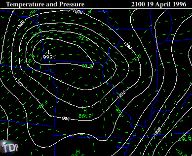 |
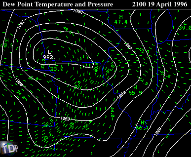
Winds flowing counterclockwise around the center of low pressure located in south-western Iowa supported the movement of warmer air into Illinois. At the same time, a tongue of low level moisture was protruding northward into central Illinois, with dew point temperatures (dashed contours) in the mid 50's to mid 60's.
 |
The presence of warm and moist air at lower levels, coupled with cooler and drier air at mid levels (near 700 mb) helped to destabilize the atmosphere. This instability supported the development of severe thunderstorms. The sounding from 00Z, or 7:00 PM CDT, shows the temperature and moisture profile described previously. The strong moisture gradient associated with the warm front across north-central Illinois is quite evident in this panel.
|
summary |
|
instability |