.
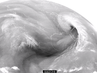
Water Vapor Images
continental united states
These are water vapor satellite images for the continental United States. Time period of availability:
0000Z
March 12 to
2300Z
March 15, 1993.
March 12, 1993
00Z
01Z
02Z
03Z
04Z
05Z
06Z
07Z
08Z
09Z
10Z
11Z
12Z
13Z
14Z
15Z
16Z
17Z
18Z
19Z
20Z
21Z
22Z
23Z
March 13, 1993
00Z
01Z
02Z
03Z
04Z
05Z
06Z
07Z
08Z
09Z
10Z
11Z
12Z
13Z
14Z
15Z
16Z
17Z
18Z
19Z
20Z
21Z
22Z
23Z
March 14, 1993
00Z
01Z
02Z
03Z
04Z
05Z
06Z
07Z
08Z
09Z
10Z
11Z
12Z
13Z
14Z
15Z
16Z
17Z
18Z
19Z
20Z
21Z
22Z
23Z
March 15, 1993
00Z
01Z
02Z
03Z
04Z
05Z
06Z
07Z
08Z
09Z
10Z
11Z
12Z
13Z
14Z
15Z
16Z
17Z
18Z
19Z
20Z
21Z
22Z
23Z
eastern ir
Terms
for using data resources.
CD-ROM
available.
Credits and Acknowledgments
for WW2010.
Department of Atmospheric Sciences (DAS)
at
the University of Illinois at Urbana-Champaign.
Current Weather


/arch/cases/930312/sat/gifs/vapor/93031203.gif)
/arch/cases/930312/sat/gifs/vapor/93031206.gif)
/arch/cases/930312/sat/gifs/vapor/93031209.gif)
/arch/cases/930312/sat/gifs/vapor/93031212.gif)
/arch/cases/930312/sat/gifs/vapor/93031215.gif)
/arch/cases/930312/sat/gifs/vapor/93031218.gif)
/arch/cases/930312/sat/gifs/vapor/93031221.gif)
/arch/cases/930312/sat/gifs/vapor/93031300.gif)
/arch/cases/930312/sat/gifs/vapor/93031303.gif)
/arch/cases/930312/sat/gifs/vapor/93031306.gif)
/arch/cases/930312/sat/gifs/vapor/93031309.gif)
/arch/cases/930312/sat/gifs/vapor/93031312.gif)
/arch/cases/930312/sat/gifs/vapor/93031315.gif)
/arch/cases/930312/sat/gifs/vapor/93031318.gif)
/arch/cases/930312/sat/gifs/vapor/93031321.gif)
/arch/cases/930312/sat/gifs/vapor/93031400.gif)
/arch/cases/930312/sat/gifs/vapor/93031403.gif)
/arch/cases/930312/sat/gifs/vapor/93031406.gif)
/arch/cases/930312/sat/gifs/vapor/93031409.gif)
/arch/cases/930312/sat/gifs/vapor/93031412.gif)
/arch/cases/930312/sat/gifs/vapor/93031415.gif)
/arch/cases/930312/sat/gifs/vapor/93031418.gif)
/arch/cases/930312/sat/gifs/vapor/93031421.gif)
/arch/cases/930312/sat/gifs/vapor/93031500.gif)
/arch/cases/930312/sat/gifs/vapor/93031503.gif)
/arch/cases/930312/sat/gifs/vapor/93031506.gif)
/arch/cases/930312/sat/gifs/vapor/93031509.gif)
/arch/cases/930312/sat/gifs/vapor/93031512.gif)
/arch/cases/930312/sat/gifs/vapor/93031515.gif)
/arch/cases/930312/sat/gifs/vapor/93031518.gif)
/arch/cases/930312/sat/gifs/vapor/93031521.gif)