
|


|
From The Developers...
One of the goals of WW2010 is to provide easy access to a large database of real time data and instructional materials. For this to occur, all resources must be carefully organized to ensure quick and easy access by the user. The hierarchical menu structure we're implementing is forcing us to do just that. |
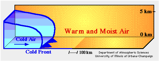
The animation below is a vertical cross section depicting the development of precipitation ahead of and along a cold front. The surging blue region represents the cold air mass behind the cold front (solid blue line) and the yellow areas indicate the warm moist air mass ahead of the front.
** Press "Reload" to restart the animation **
As the cold air mass propagates, it lifts the warmer less dense air ahead of it (red arrows). The air cools as it rises and the moisture condenses to produce clouds and precipitation ahead of and along the cold front. In contrast to lifting along a warm front, upward motions along a cold front are typically more vigorous, producing deeper clouds and more intense bands of showers and thunderstorms. However, these bands are often quite narrow (a couple hundred kilometers across) and move rapidly just ahead of the cold front.
|
definition |
|
cyclones |