
|


Squall lines generally form along or ahead of cold fronts and drylines and can produce severe weather in the form of heavy rainfall, strong winds, large hail, and frequent lightning.
| Squall lines can extend to hundreds of miles in length, simultaneously affecting several states at a time. They also can travel quickly -- at speeds up to 60 mph. |

Photo by Doswell |
Squall lines typically form in unstable atmospheric environments in which low-level air can rise unaided after being initially lifted (e.g., by a front) to the point where condensation of water vapor occurs. Heat is released during condensation, resulting in the rising air becoming lighter than nearby air at the same height. This leads to an increase in the speed of the rising air which sometimes reaches speeds above 30 mph. In models this initial lifting is specified through an idealization of the flow associated with the front or other lifting mechanism or through the use of observational flow information.
| In this simulation, the clouds are shown in grey, and the surface color represents surface winds as seen by an observer moving with the line. Blue represents winds approaching the storm while greens and reds represent the winds in the cold air behind the storm outflow. | |
| The gust front is located along the line where these winds meet -- which extends from the surface well up into the the storm. | |
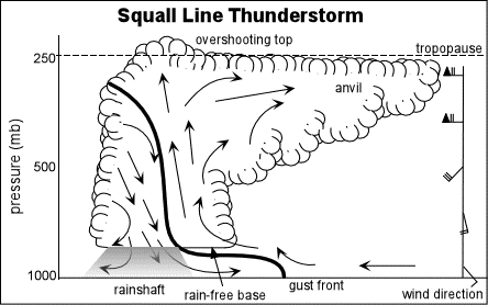
The schematic above is a depiction of the structure of a
well-formed squall line. Such schematics are often a key
result of a scientific investigation and can be based on
observations, model and/or theory. They help communicate
some of the key features in a simple and concise way. Note the
similarity of the schematic to features in previous animation
including the overshooting top,
anvil, and gust front.
|
convective lines |
|
tornadoes |