
|


A dry line is a boundary that separates a moist air mass from a dry air mass. Also called a "Dew Point Front", sharp changes in dew point temperature can be observed across a dry line. Dry lines are most commonly found just east of the Rocky Mountains, separating a warm moist air mass to the east from a hot dry air mass to the west.
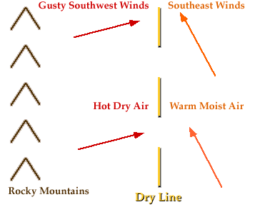
States like Texas, New Mexico, Oklahoma, Kansas, and Nebraska frequently experience dry lines in the spring and summer. Dry lines are extremely rare east of the Mississippi River.
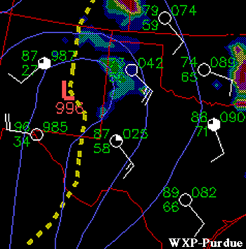
Image by: WXP Purdue
Dew points east (ahead) of the dry line shown above range from the upper 50's to low 70's with winds from the southeast. West of the dry line, dew points were in the 20's and 30's, a decrease of nearly 50 degrees. Air temperatures ahead of the dry line were generally in the 70's and 80's while behind the dry line, temperatures ranged from the mid 80's to mid 90's. Drier air behind dry lines lifts the moist air ahead of it, triggering the development of thunderstorms along and ahead of the dry line (similar to cold fronts). It is not uncommon for tornadic supercells to develop along a dry line.
|
occluded front |
|
Advection |