|
NOTE: We've guessed that
you're not using a client that supports colored tables and have tried
to compensate. Low graphics mode looks much better on clients that
do... we recommend switching to Netscape 3.0 or Microsoft Internet
Explorer.
|
|
|
. |
Groundwater
water that has penetrated the earth's surface
[Image: Groundwater Animation (83K)]
Animation by:
Bramer
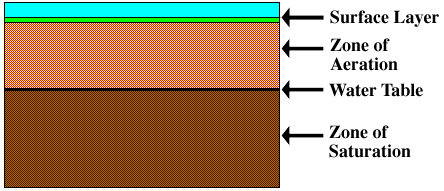
Groundwater is all the water that has penetrated the earth's
surface and is found in one of two soil layers. The one nearest
the surface is the "zone of aeration", where gaps between soil are
filled with both air and water. Below this layer is the
"zone of saturation",
where the gaps are filled with water. The water table is the boundary
between these two layers. As the amount of groundwater water increases
or decreases, the water table rises or falls accordingly.
When the entire area
below the ground is saturated, flooding
occurs because all subsequent precipitation is forced to remain on the surface.
The amount of water that can be held in the soil is called
"porosity". The rate at which water flows through the soil
is its "permeability". Different surfaces hold different amounts
of water and absorb water at different rates. Surface
permeability is extremely important for hydrologists to monitor
because as a surface becomes less permeable,
an increasing amount of water remains on the surface,
creating a greater potential for flooding.
Flooding is very common during winter and early spring because the
frozen ground has no permeability, causing
most rainwater and meltwater to become runoff.
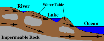
Water that infiltrates the soil
flows downward until it encounters
impermeable rock (shown in gray), and then travels laterally.
The locations where water moves laterally are called "aquifers".
Groundwater returns to the surface through these aquifers
(arrows), which empty into lakes, rivers, and the oceans. Under special
circumstances, groundwater can even flow upward in artesian wells.
The flow of groundwater is much slower than runoff,
with speeds usually measured in centimeters per
day, meters per year, or even centimeters per year.

precipitation
|
|

transpiration
|
|
![[Image: Groundwater Animation (83K)]](/guides/mtr/hyd/gifs/grnd1.gif)