
|


Helicity is simply a measure of the amount of rotation found in a storm's updraft air. If there is significant rotation in a storm's updraft air, the storm will more than likely become a supercell and possibly spawn one or more tornadoes.
In the movie below, we can see how wind with horizontal rotation can be converted into the vertical. If air in this movie were flowing along this line (from left to right), it would have a rotation like the arrows shown -- not unlike that of a well-thrown football. If this rotating air made its way into an updraft (at the right end of the line), the horizontal rotation would become vertical -- giving birth to a potentially tornadogenic supercell.
Another view of this vertically oriented rotation is shown with the updraft region in red. If air can enter the storm in the direction of the orange arrow, then there will be rotation in the updraft -- possibly leading to a supercell.
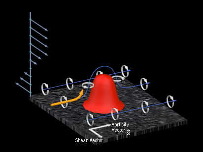
Image by COMET
To put this in perspective, we could see how directional wind shear can allow storm inflow air to enter a storm along these vortex rolls. The speed shear at middle and upper levels creates a horizontal roll in a southeast-northwest direction, but the lowest level winds are entering the storm from the east and southeast. This means that in order to achieve high helicity, directional wind shear must be present.
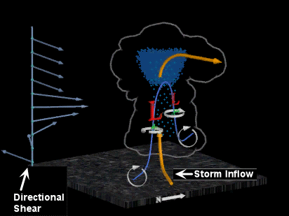
Image by COMET
Helicity primarily takes into account vertical wind shear, but many modelers do like to factor helicity measurements into their severe storm experiments because it provides a means to measure both directional and speed shear in one parameter. This also helps modelers compare and contrast different experimental results against an environmental variable.
|
cape |
|
Weather Forecasting |