
|


A few storms take the intensification process further, to the supercell stage. The updraft becomes virtually erect and the storm top shifts off of the low-level echo gradient to the area above the developing pendent echo. Radar reflectivities continue to increase in both the low level and extensive mid-level overhang echoes. As mentioned earlier, evidence suggests that storm circulation associated with the mesocyclone holds the gust front in check. Therefore, rather than racing ahead of the updraft to eventually choke it off, the gust front remains quasi-stationary relative to the moving storm and aids in continued lifting of warm air into the updraft.
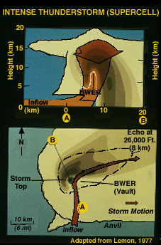 |
A bounded WER (BWER) develops where the intense
updraft is surrounded by
mid-level overhang. When a hook or pendant echo is not visible on radar, a
BWER often is, provided that the radar operator searches for it with the
suggested vertical tilt sequence rather than with the
range-height indicator
(RHI) mode.
The supercell in this illustration does have a pendant echo, with the top of the rotating updraft above the WER and just east of the pendant. The radar operator must be aware that spotters are likely to see a well-developed wall cloud, often with vigorous rotation, beneath the radar BWER. |
Why is the supercell updraft so intense? Obviously, instability is one factor. Another contributor is rotation. Research has shown that the lowest pressures in the rotating updraft initially are in the mid-levels (20,000 feet or so) in a supercell, causing an acceleration of the updraft, because of the upward oriented pressure gradient. This can result in a 50 percent increase in updraft speeds!
Photograph by: NSSL
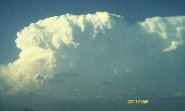
The Panhandle storm has become virtually erect, with an extremely crisp Cb top and anvil edge. We are still looking north, from about 30 miles, at the incipient supercell.
|
multicell lt-analysis |
|
supercell matures |