
|


The most recent El Niño event began in the spring months of 1997. Instrumentation placed on Buoys in the Pacific Ocean after the 1982-1983 El Niño began recording abnormally high temperatures off the coast of Peru. Over the next couple of months, these strength of these anomalies grew. The anomalies grew so large by October 1997 that this El Niño had already become the strongest in the 50+ years of accurate data gathering.
The image below displays the Sea Surface Temperature (SST) Anomalies in degrees Celsius for the middle of September, 1997. By this time, the classic El Niño pattern has almost fully ripened, with maxima above +4 degrees Celsius.
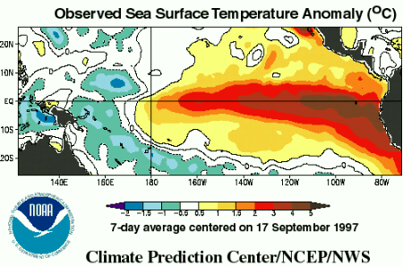
Image by: CPC ENSO Main Page
Droughts in the Western Pacific Islands and Indonesia as well as in Mexico and Central America were the early (and sometimes constant) victims of this El Niño. These locations were consistent with early season El Niños in the past. A global view of the normal climatic effects of El Niño can be seen below.
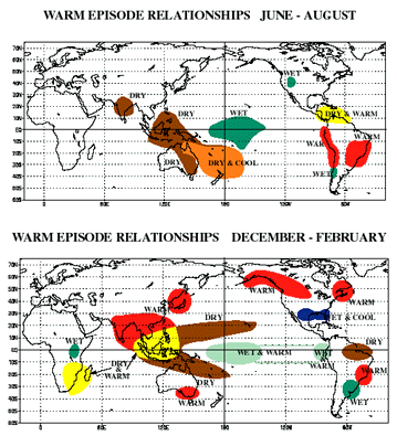
Image by: CPC ENSO Main Page
The effects El Niño have on
United States' weather is less obvious. Back in 1982-1983, the U.S. Gulf
States and California received excessive rainfall.
As the winter approached, forecasters expected excessive rainfall to occur
again.
Indeed, portions of central and southern California suffered
record-breaking rainfall amounts. Damage consisted not only of
flooding, but mudslides Some mudslides destroyed communities in
a flash -- causing many casualties. Other problems could be
found in the Gulf states, as severe weather was above average. Even though
no one particular storm can be blamed on El Niño, many forecasters
do believe the event did increase the chances for such severe weather to
occur.
|
definition |
|
upwelling |