
|


Jet streaks are localized regions of very fast winds embedded within the jet stream. Sometimes these local wind maxima reach speeds in excess of 160 knots. Below is an ETA Model forecast panel for 300 mb winds and geopotential heights (white contours). The color filled regions indicate wind speed in knots and is color coded according to the legend at the bottom of the image. The shades of blue indicate winds less than 60 knots, while winds greater than 120 knots are given in shades of red.
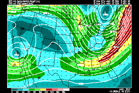
The yellow, green and red ribbon on the image above represent the jet stream, and along the East Coast, the region of strongest winds (shaded in red) is a jet streak.
As air enters a jet streak, it speeds up. When it leaves a jet streak, it slows down. These accelerations and decelerations, coupled with the curvature of the jet stream and strong wind shears, cause air to pile up in some areas (convergence) and spread out (divergence) in others. These regions of divergence and convergence have a significant influence on surface pressure features.
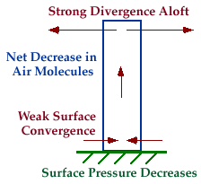 |
Intensifying Surface Cyclone:
For example, if a region of diverging winds at upper levels is stronger than the converging winds of a suface low pressure center below it, the low will deepen (intensify). This is because more air is being removed from the vertical column of air above the low than flowing into it, causing the pressure at the surface to decrease. A drop in pressure means an intensification of the low pressure center. |
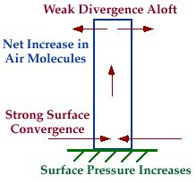 |
Weakening Surface Cyclone:
In contrast, if a region of diverging winds at upper levels is weaker than the converging winds of a suface low pressure center below it, the low begins to fill (weaken). This is because more air is flowing into the vertical column of air above the low than flowing out of it, causing the pressure at the surface to increase. An increase in pressure means a weakening of the low pressure center. |
|
jet stream |
|
vertical motions |