
|


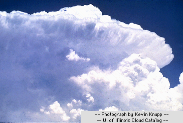
Cumulonimbus clouds are much larger and more vertically developed than fair weather cumulus. They can exist as individual towers or form a line of towers called a squall line. Fueled by vigorous convective updrafts (sometimes in excess 50 miles/hour), the tops of cumulonimbus clouds can easily reach 39000 feet (12000 meters) or higher.

The lower portion of the cloud consists mostly of water droplets while at
the cloud top, where temperatures are well below 0 degrees Celsius, there
are primarily ice crystals. Under favorable atmospheric conditions,
what may initially appear as harmless fair
weather cumulus
clouds can quickly develop
into large cumulonimbus clouds. Occasionally, these clouds grow into
powerful thunderstorms known as
supercells.
Supercells are large
thunderstorms whose
updrafts and downdrafts are so
closely in balance that such a storm can have a lifetime of several hours.
Fueled by intense
updrafts
(occasionally reaching 90 m.p.h.),
supercells can produce large
hail,
damaging winds, and
tornadoes.
Supercells are typically characterized by strong
vertical shear and steep
lapse rates.
Supercells tend to develop during the afternoon and the early
hours, when the effects of heating by the sun are strongest.
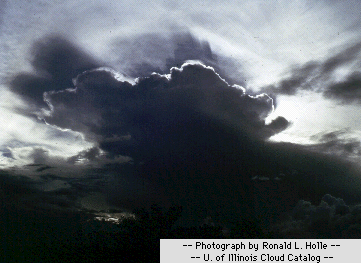
A line of approaching
thunderstorms at sunset might resemble something like the picture above.
The sun setting behind this developing cumulonimbus tower
clearly reveals the distinct cloud edges that mark the
extent of the rising air.
|