
|


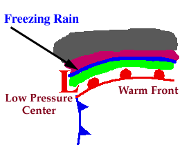
Ice storms can be the most devastating of winter weather phenomena and are often the cause of automobile accidents, power outages and personal injury. Ice storms result from the accumulation of freezing rain, which is rain that becomes supercooled and freezes upon impact with cold surfaces. Freezing rain is most commonly found in a narrow band on the cold side of a warm front, where surface temperatures are at or just below freezing.
The diagram below shows a typical temperature profile for freezing rain with the red line indicating the atmosphere's temperature at any given altitude. The vertical line in the center of the diagram is the freezing line. Temperatures to the left of this line are below freezing, while temperatures to the right are above freezing.
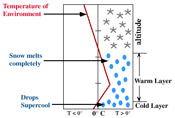
Freezing rain develops as falling snow encounters a layer of warm air deep enough for the snow to completely melt and become rain. As the rain continues to fall, it passes through a thin layer of cold air just above the surface and cools to a temperature below freezing. However, the drops themselves do not freeze, a phenomena called supercooling (or forming "supercooled drops"). When the supercooled drops strike the frozen ground (power lines, or tree branches), they instantly freeze, forming a thin film of ice, hence freezing rain.
|
Precipitation |
|
Dangers |