
|


Photograph by: Holle |
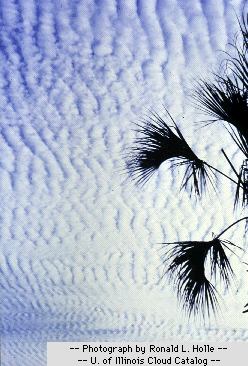
Altocumulus clouds are composed primarily of water droplets and are located between 6,500 and 20,000 feet (2,000 to 6,000 meters) above the ground. |

Photograph by: Holle |
Altocumulus may appear as parallel bands (top photograph) or rounded masses (bottom photograph). Typically a portion of an altocumulus cloud is shaded, a characteristic which makes them distinguishable from the high-level cirrocumulus. Altocumulus clouds usually form by convection in an unstable layer aloft, which may result from the gradual lifting of air in advance of a cold front. The presence of altocumulus clouds on a warm and humid summer morning is commonly followed by thunderstorms later in the day. |
Also found at mid-levels are altostratus clouds, which are often confused with high-level cirrostratus. One distinguishing feature is that a halo is not observed around the sun (or moon) when viewed through altostratus, but is a common feature associated with cirrostratus clouds. In fact, the sun (or moon) is only vaguely visible through altostratus clouds and appears as if it were shining through frosted glass.
|
High-Level Clouds |
|
Low-Level Clouds |