|
|
. |
Surface Images
continental united states
|
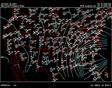
Each image contains surface
observations (white symbols) and
isobars (solid blue
contours) for the continental United States. Time period
of availability: 1200Z
March 12 to
0900Z March 15, 1993.
|
|
March 12, 1993 |
|
|
March 13, 1993 |
|
|
March 14, 1993 |
| 00Z |
01Z |
02Z |
03Z |
04Z |
05Z |
06Z |
07Z |
| 08Z |
09Z |
10Z |
11Z |
12Z |
13Z |
14Z |
15Z |
| 16Z | 17Z |
18Z | 19Z |
20Z | 21Z |
22Z | 23Z |
|
|
March 15, 1993 |
| 00Z |
01Z |
02Z |
03Z |
04Z |
05Z |
06Z |
07Z |
| 08Z |
09Z |
10Z |
11Z |
12Z |
13Z |
14Z |
15Z |
| 16Z | 17Z |
18Z | 19Z |
20Z | 21Z |
22Z | 23Z |
|

Superstorm '93
|
|

northeast
|
|


/arch/cases/930312/sfc/gifs/us/93031212.gif)
/arch/cases/930312/sfc/gifs/us/93031213.gif)
/arch/cases/930312/sfc/gifs/us/93031214.gif)
/arch/cases/930312/sfc/gifs/us/93031215.gif)
/arch/cases/930312/sfc/gifs/us/93031216.gif)
/arch/cases/930312/sfc/gifs/us/93031217.gif)
/arch/cases/930312/sfc/gifs/us/93031218.gif)
/arch/cases/930312/sfc/gifs/us/93031219.gif)
/arch/cases/930312/sfc/gifs/us/93031220.gif)
/arch/cases/930312/sfc/gifs/us/93031221.gif)
/arch/cases/930312/sfc/gifs/us/93031222.gif)
/arch/cases/930312/sfc/gifs/us/93031223.gif)
/arch/cases/930312/sfc/gifs/us/93031300.gif)
/arch/cases/930312/sfc/gifs/us/93031301.gif)
/arch/cases/930312/sfc/gifs/us/93031302.gif)
/arch/cases/930312/sfc/gifs/us/93031303.gif)
/arch/cases/930312/sfc/gifs/us/93031304.gif)
/arch/cases/930312/sfc/gifs/us/93031305.gif)
/arch/cases/930312/sfc/gifs/us/93031306.gif)
/arch/cases/930312/sfc/gifs/us/93031309.gif)
/arch/cases/930312/sfc/gifs/us/93031310.gif)
/arch/cases/930312/sfc/gifs/us/93031311.gif)
/arch/cases/930312/sfc/gifs/us/93031312.gif)
/arch/cases/930312/sfc/gifs/us/93031313.gif)
/arch/cases/930312/sfc/gifs/us/93031314.gif)
/arch/cases/930312/sfc/gifs/us/93031315.gif)
/arch/cases/930312/sfc/gifs/us/93031316.gif)
/arch/cases/930312/sfc/gifs/us/93031317.gif)
/arch/cases/930312/sfc/gifs/us/93031319.gif)
/arch/cases/930312/sfc/gifs/us/93031320.gif)
/arch/cases/930312/sfc/gifs/us/93031322.gif)
/arch/cases/930312/sfc/gifs/us/93031323.gif)
/arch/cases/930312/sfc/gifs/us/93031402.gif)
/arch/cases/930312/sfc/gifs/us/93031403.gif)
/arch/cases/930312/sfc/gifs/us/93031404.gif)
/arch/cases/930312/sfc/gifs/us/93031405.gif)
/arch/cases/930312/sfc/gifs/us/93031406.gif)
/arch/cases/930312/sfc/gifs/us/93031409.gif)
/arch/cases/930312/sfc/gifs/us/93031502.gif)
/arch/cases/930312/sfc/gifs/us/93031503.gif)
/arch/cases/930312/sfc/gifs/us/93031504.gif)
/arch/cases/930312/sfc/gifs/us/93031505.gif)
/arch/cases/930312/sfc/gifs/us/93031506.gif)
/arch/cases/930312/sfc/gifs/us/93031509.gif)